Ilarion and Polyphitos Dam Lakes, Western Macedonia
Mid-term report, April 2024
Since Novemer 2022, HCMR and our colleagues at the Department of Ichthyology and Aquatic Environment (DIAE) of the University of Thessaly, and other collaborators have been working on ichthyological research related to mitigating the impacts to fish by the Ilarion Hydroelectric Dam, on the Aliakmon river, in Western Macedonia. Along with expert help from researchers in Austria, Slovenia, Britain and the National Technical University of Athens we have slowly built a knowledge base to confront this complex issue and associated problems of broadscale fragmentation and change by the Ilarion high dam. Our background exploratory baseline surveys for the Public Power Corporation (DEH) in a project in 2007 to 2009 (before the dam was built) provide important references. This current project is deep dive (2022 to 2025), a proposal for specific restoration measures, with possible further work and monitoring.
Now we are at an exciting mid-term point in the present study.
We have designed the sampling schedule and executed the first phase of the inventories, doing all forms of fish sampling: boat-based electrofishing, fisher interviews and eDNA sampling. We have organized and are designing mitigation measures (habitat enhancement, species management, fish-pass in tributary streams, adaptive management of habitat alterations). And we are organizing the monitoring plan for the future.
These are some important first discoveries that should inform future conservation planning and much-needed actions:
-Our philosophy for large hydroelectric reservoir management promotes a "pro-nature" approach and must include biodiversity conservation actions within a "best-possible" adaptive management framework. High dams may somewhat appear like so-called "novel lake ecosystems" but we actually have no right in "labelling" them as something so different or "alien". It may help to distinguish them as "special" in their own right but they are evolving features of the wider landscape. Each reservoir and its local situation is unique; some reservoirs can be important refuges for biodiversity. In the case of the Polyphitos and Ilarion dam lakes, we see really big aquatic and riparian areas that definately host a lot of fish and wildlife. But, of course, there are problems; for example:
-The new dam of Ilarion (2013) is a complete block to upstream fish migration and has seriously impacted at least five rheophilic river fishes; some of these species have been lost above and below the dam for many kilometers of their former range.
-Water levels and water flow management are anthropocentric. Part of the water is destined for potable water for Thessaloniki, flows are adjusted in response to electricity use. Electricity use is also influenced by the spread of renewable energey sources (wind and solar farms that have recently proliferated in the region). Flow and surface water depth regimes are not steady or "predictable". Each year depending on precipitation and consumption patterns, water level regimes may change. This unpredictable extreme fluctuation is not good for nature.
-Flow quanitites and water quality as well as hydropeaking is a problem downstream of the Ilario Dam. Rheophilic fishes have been effected as have limnological parameters in the older reservoir downstream, Lake Polyphitos.
-Since there is no monitoring data beyond the initial work of 2007 and 2008; the knowledge of the evolution of the lake ecosystems after the new Ilarion Dam begun functioning (2013) is unfortunately scant. There are certainly many other complications.
-People translocate fish and crayfish in new water bodies without any guidance from authorities, scientific planning or enforcement.
Some relevant management approaches:
-No fish pass can possibly overcome a 130 high dam and there is no feasibility reasoning to promote this in the case of Ilarion Dam. In its place there was a deep gorge before the dam and this long white-water section did create some sort of a barrier for the passage and establishement of lentic species upstream of Polyphitos lake (i.e. roach, bleak where totally absent upstream of the location of Ilarion Dam before the dam was created).
-Mitigation and management opportunities abound in the two lakes and the part downstream of the Dam. The fish of both lakes do have their share of pressures/impacts to deal with. Various changes and human pressures; its not just the effects of daming (fragmentation) and impounding (obliteration of riverine/lotic habitats).
-No artificial hatchery system is required to enhance or augment fish populations in the new reservoir (Lake Ilarion, formed in 2013); fish communities are already being established.
-In Greece, we prefer to call dam reservoirs artificial lakes (τεχνητές λίμνες) not reservoirs (ταμιευτήρες). I believe this is a productive management approach since they are very similar to true lake ecosystems, of course they do have fundamental differences. If they are managed with nature in mind, they could definately provide important habitat for biodiversity and ecosystem services for local communities.
I'll try to inform in another post on our scientific research and management approaches. I post some snapshots from the field and lab and will post more in the near future.
MAPS OF THE STUDY AREA
 |
| The study area (focus area in yellow square) on the Aliakmon River, within the Administrative Region of Western Macedonia (pink dotted outline). |
 |
| The position of the Ilarion Dam (completed and functional in 2013), its new lake reservoir (Ilarion Lake- in red) and the downstream section of the river with the much older Polyphytos Lake which is also a dam reservoir on the Aliakmon (constructed in 1972). The study area is divided in different water bodies: 1. Upper Aliakmon, 2. Venetikos Tributary, 3. Lake Ilarion, 4. Lake Ilarion Tributary streams, 5. Downstream river section below the Ilarion Dam, 6. Polyphytos Lake. |
LAKE POLYPHITOS
 |
| View from the Rimnio Bridge of Lake Polyphytos. eDNA pump filtering water on shoreline during low water levels in November 2023. The first photo in this post is taken from the bridge looking downstream into the Polyphytos Lake. Covering an area of about 90 sq. km it is one of the two largest artificial lakes in Greece (the other on is Lake Kremasta). |
 |
| Mixted schools of Thessaly Bleak (Alburnus thessalicus) and Roach (Rutilus rutilus). Under the Rimnio Bridge. |
 |
| Macedonian Chub (Squalius vardarensis) sizes 25-30 cm TL, below the Rimnio Bridge. In deeper waters only barely apparant are some large Dark Vimbas (Vimba melanops) and Roach. |
 |
| The most productive part of Polyphitos is where the Aliakmon enters the Lake, that is, the upper part of the lake upstream of the Rimnio bridge (from where this photo was taken). |
LAKE ILARION
 |
| Lake Ilarion at the mid section - where there were once deep valleys and gorges. This is near Lazarades village. |
 |
| Lake Ilarion, near Lazarades village. (eDNA sampler in use). |
 |
| Lake Ilarion - the upper part; near Tornikou stream tributary confluence. The mountain-landmark is Mount Vounasa (1605m/5266ft a.s.l.). This mountain may not be a giant but has a remarkable topographic prominence, and dominates over the landscape. In fact its peack prominence is measured at 802 m. and this is the second highest in the Grevena Regional Unit. The mountain's form is recognizable and dominates the landscapes of the new Lake. |
 |
| Double estuary mudflats of the Sioutsa and Aliakmon in the upper part of Lake Ilarion. |
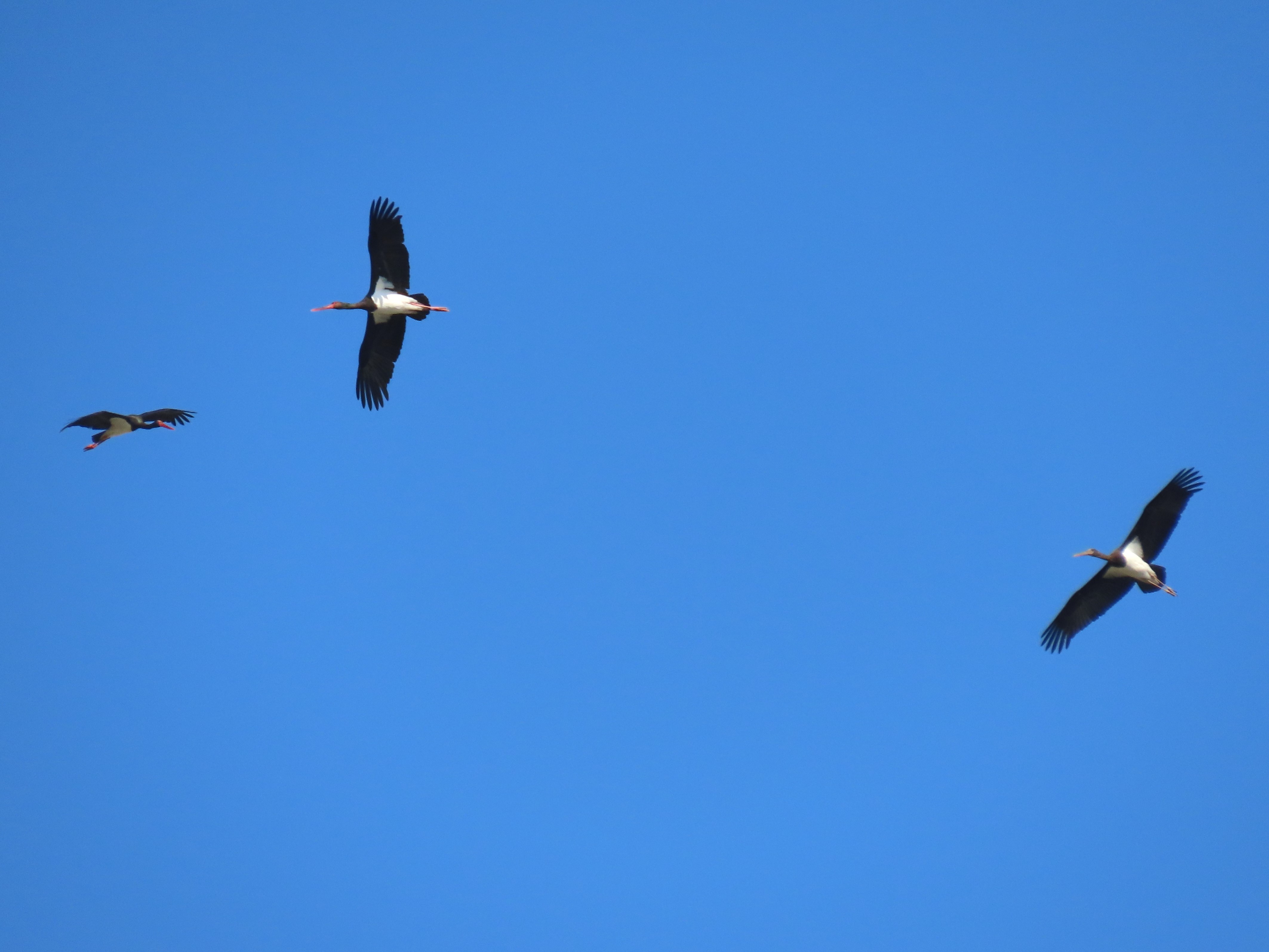 |
| Black Storks during Autumn passage. |
 |
| Great Egret. This is one of several bird species that has definately benefited from the artificial lakes. |
 |
| Boat-based electrofishing along the shores of the lower part of Lake Ilarion. |
 |
| Boat-based electrofishing along the shores of the lower part of Lake Ilarion. |
 |
| Protocol: Boat-based electrofishing along the shores of the lower part of Lake Ilarion |
 |
| eDNA sampling along the shores of the lower part of Lake Ilarion. |
 |
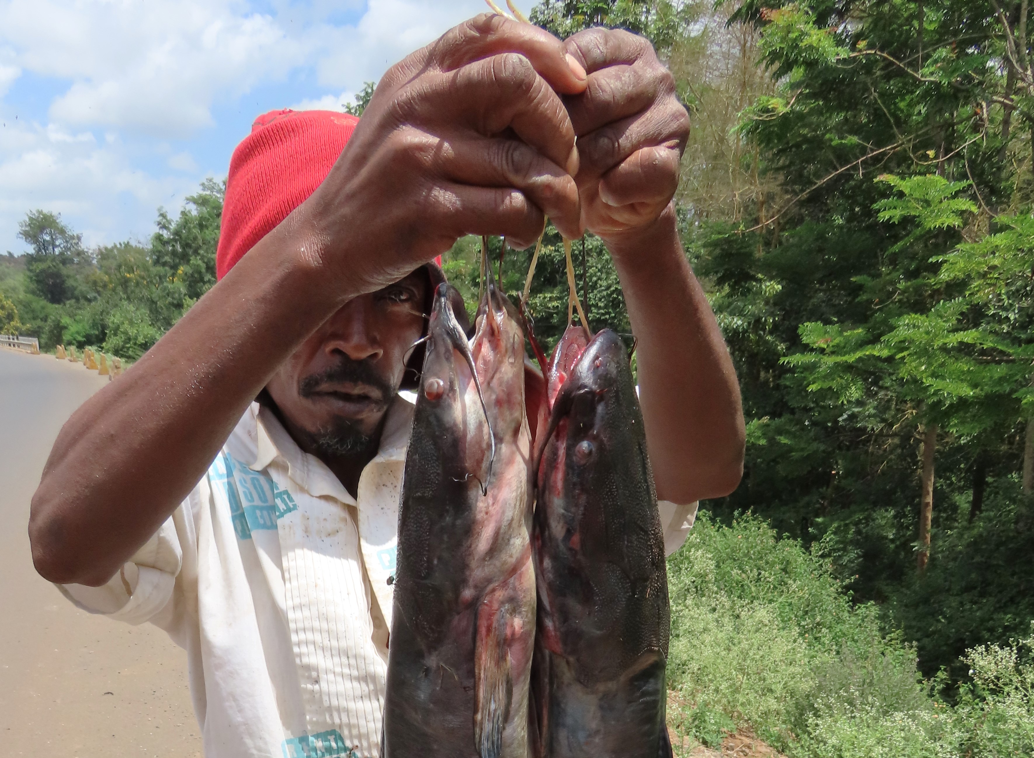
| Boat-based electrofishing along the shores of the lower part of Lake Ilarion - many carp were found! |
 |
| Upper part of Ilarion Lake. This huge feild on left floods completely in Spring and provides a good areas for spawning Carp. |
DOWNSTREAM OF ILARION DAM
 |
| The Ilarion Dam's height is 130 m. A significant height at a pivotal position in the landscape. Below it the river runs into a wide valley forms wide open landscape. Above the dam there were narrow upland river deep gorges and rocky mountains. |
 |
| About 3 km downstream of the Dam. |


 |
| Photo from Rinnio Bridge 7 km downstream of Ilarion Dam when at the lowest-possible water level of Polyphitos Lake (looking upstream; Nov. 2021). |
 |
| Photo from Rinnio Bridge downstream of Ilarion Dam when at the lowest-possible water level of Polyphitos Lake (looking downstream, Nov. 2021). |
 |
| In Autumn, the landscape of the area below the dam - for nearly 7 kilometers- is a varied riparian wonderland (Sept 2023). |
UPPER ALIAKMON RIVER AND ITS CONFLUENCE WITH ILARION LAKE

 |
| Electrofishing by combined boat and long-cable generator in the estuary of the Aliakmon with Ilarion Lake (Sept. 2023). |
 |
| Five-person team electrofishing within our boat in a reach of the upper Aliakmon near Neapoli (Sept. 2023) |
 |
| Double-estuary mudflats of the Sioutsa tributaryu and the Aliakmon main stem in the upper part of Lake Ilarion (early November, near the Lake's lowest water levels). The footprints leading into the mudflats on the bottom left of the photo are Brown Bear. |
LAB WORK - WRITE-UP - COMMUNICATION - TEAM CREDITS